Top 10 Types of Aerial Surveying Equipment & Their Uses
General


Using the right aerial surveying equipment is critical when gathering precise spatial data for surveys and mapping.
Remote sensing technologies used in aerial surveys enable professionals to acquire precise and accurate data that can then be analyzed and used in many different applications.
In this article, we explore the top 10 types of aerial surveying equipment and elucidate their significant applications across different fields.
1. LIDAR (Light Detection and Ranging)
Lidar technology utilizes laser pulses to measure distances and create highly accurate 3D maps of terrain.
Its applications span across urban planning, forestry management, and geological surveys, providing detailed elevation models and enhancing infrastructure development.
Lidar systems typically consist of lasers, scanners, GPS receivers, and inertial measurement units (IMUs), all integrated into a single system.
The lasers emit short pulses of light, which travel to the ground and bounce back to the sensor.
By precisely timing the round-trip of each pulse, lidar systems calculate the distance to the ground surface, generating a dense point cloud of elevation data.
This data is then processed to create detailed digital elevation models (DEMs) and surface models, providing valuable insights into topography, vegetation structure, and land cover.
For more information, see our blog article: Elevate Your Understanding: Exploring Aerial Lidar for the Mapping Industry
%2520(1).png)
Lidar technology offers numerous advantages over traditional surveying methods, including its ability to penetrate dense vegetation, capture data in challenging terrain, and provide highly accurate measurements over large areas.
In addition to terrain mapping, Lidar finds applications in forestry management, floodplain mapping, infrastructure planning, and archaeological surveys, where its high-resolution data enables precise analysis and decision-making.
As technology continues to advance, lidar systems for wide-area mapping are becoming more powerful while lidar systems for drones are becoming increasingly compact, lightweight, and cost-effective.
To determine which lidar is best for your application, consider the amount of terrain that needs to be surveyed, the type of platform you will be using, the point density requirements for your 3D data, and of course, your budget.
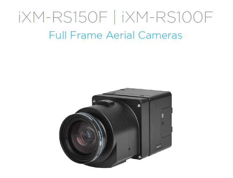
2. Photogrammetry Systems - Medium Format Cameras
Another important type of aerial surveying equipment are medium format photogrammetry cameras. The sensors systems utilize aerial photography to reconstruct 3D models of landscapes with remarkable precision.
Medium format cameras are employed in aerial surveying for their superior image quality and resolution.
With their higher resolution capabilities, medium format cameras excel in producing highly detailed aerial imagery, making them invaluable for applications requiring precise mapping, land cover analysis, and environmental monitoring
These cameras utilize larger sensors compared to standard digital cameras, allowing them to capture images with greater detail, dynamic range, and clarity.
Their ability to capture images with minimal distortion and superior color accuracy enhances the quality and reliability of aerial survey data.
Lidar technology offers numerous advantages over traditional surveying methods, including its ability to penetrate dense vegetation, capture data in challenging terrain, and provide highly accurate measurements over large areas.
In addition to terrain mapping, Lidar finds applications in forestry management, floodplain mapping, infrastructure planning, and archaeological surveys, where its high-resolution data enables precise analysis and decision-making.
As technology continues to advance, lidar systems for wide-area mapping are becoming more powerful while lidar systems for drones are becoming increasingly compact, lightweight, and cost-effective.
To determine which lidar is best for your application, consider the amount of terrain that needs to be surveyed, the type of platform you will be using, the point density requirements for your 3D data, and of course, your budget.
3. Large format Cameras
Large format cameras are essential tools in aerial surveying, particularly for city mapping. Aerial surveyors can obtain comprehensive and detailed imagery to support a wide range of surveying and mapping applications.
Some of these cameras feature nadir cameras, some oblique, and some in combination.
In nadir configuration, the camera is mounted vertically downward, capturing images directly below the aircraft.
This setup is ideal for mapping and topographic surveys, providing comprehensive coverage of the surveyed area with minimal distortion.
Nadir + oblique cameras, on the other hand, capture images both vertically downward (nadir) and at an angle (oblique) to the ground.
This configuration offers a more comprehensive view of the terrain, enabling the capture of detailed imagery of vertical structures, such as buildings and vegetation, from multiple perspectives.
Large-format cameras are an valuable example of aerial surveying equipment for applications such as urban planning, infrastructure inspection, and 3D modeling, where detailed visual data from different angles is crucial for accurate analysis and decision-making.
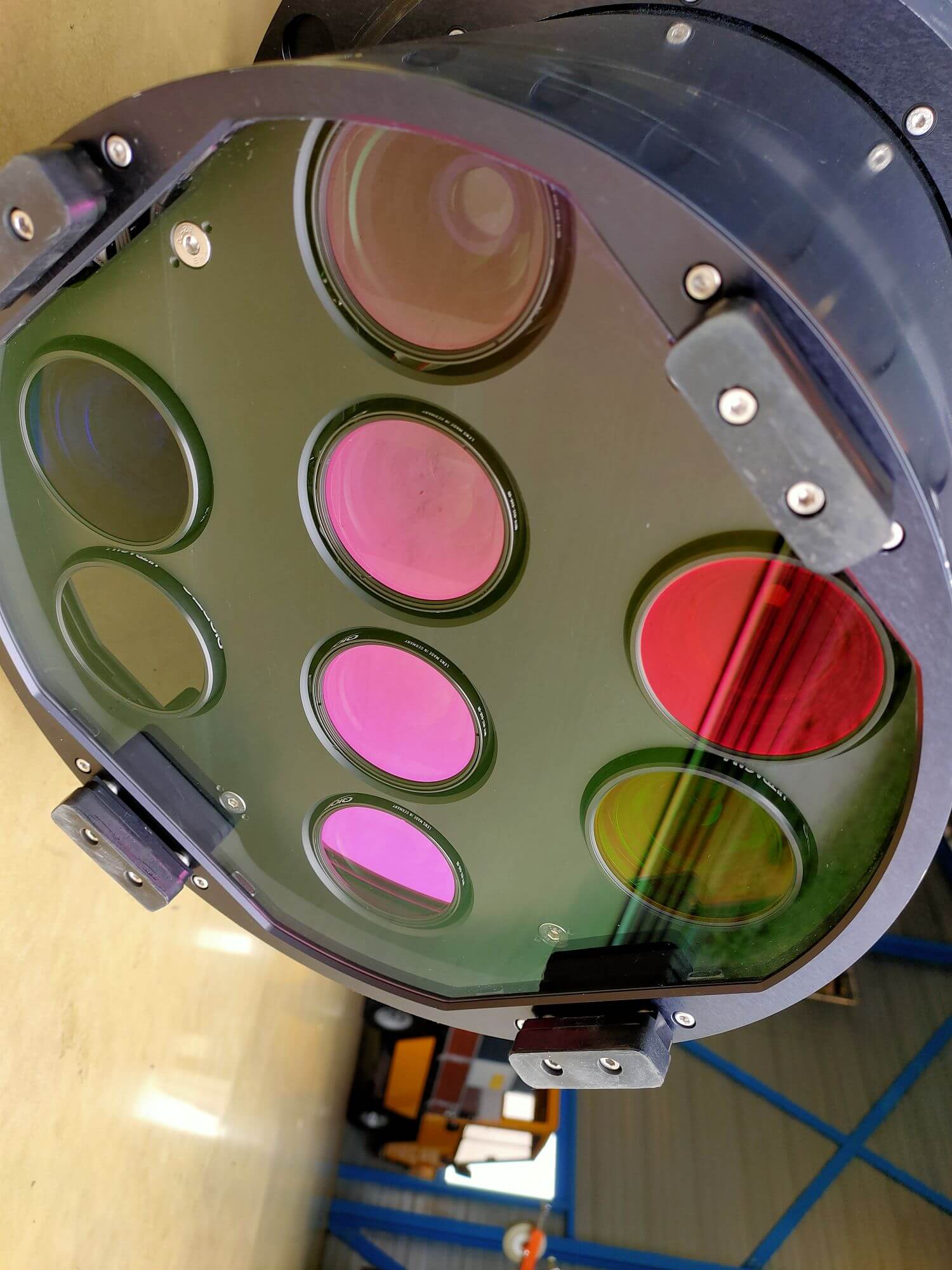
4. Hyperspectral Imaging Sensors / Multispectral
Hyperspectral imaging sensors capture data across numerous spectral bands, enabling detailed analysis of surface properties.
They are instrumental in precision agriculture, environmental monitoring, and geological surveys, providing insights into vegetation health, soil composition, and water quality.
Multispectral cameras capture images across multiple wavelengths of light, enabling analysis of vegetation health, soil moisture, and land cover.
They support precision agriculture, ecosystem monitoring, and water resource management by providing valuable spectral information.
5. Thermal Infrared Cameras
Thermal infrared cameras can be indispensable tools for some types of aerial surveying, offering unique capabilities to detect and visualize thermal signatures emitted by objects based on their temperature.
These cameras operate within the long-wave infrared spectrum, typically ranging from 8 to 14 micrometers, allowing them to capture thermal radiation emitted by objects in the environment.
The technology behind thermal infrared cameras relies on the principle of temperature differences between objects and their surroundings, with warmer objects emitting more radiation than cooler ones.
Aerial surveying applications benefit immensely from thermal infrared cameras, particularly in disaster response, environmental monitoring, and wildlife conservation.
During disaster response efforts, these cameras can detect hotspots in wildfires, identify heat anomalies in urban environments after natural disasters such as earthquakes, and assess structural damage in buildings.
In environmental monitoring, thermal infrared cameras are employed to study thermal gradients in water bodies, aiding in the identification of pollution sources and monitoring of aquatic ecosystems.
Additionally, in wildlife conservation, these cameras facilitate the detection and monitoring of animal populations by capturing their heat signatures, even in dense vegetation or under the cover of darkness.
With advancements in sensor technology and image processing algorithms, modern thermal infrared cameras offer enhanced sensitivity, resolution, and real-time imaging capabilities, further expanding their utility in aerial surveying tasks.
6. Positioning Systems
Positioning systems are integral components of aerial surveying equipment, providing precise location information essential for accurate data collection and analysis.
These systems utilize advanced technologies such as Global Navigation Satellite Systems (GNSS), including GPS (Global Positioning System), Galileo, and GLONASS, to determine the exact coordinates of surveying platforms in real-time.
Additionally, inertial navigation systems (INS) and GPS enhance positioning accuracy by accounting for factors such as platform motion.
By integrating positioning systems with aerial surveying equipment, professionals can ensure spatial accuracy, optimize surveying routes, and streamline data collection processes.
Most importantly, positioning systems enable georeferencing of captured data, facilitating seamless integration with geographic information systems (GIS) for comprehensive spatial analysis and decision-making across various industries.
7. Flight Management Systems
Flight management systems (FMS) are integral components of aerial surveying operations, providing pilots with advanced tools to plan, manage, and execute flight missions efficiently and safely.
These sophisticated systems integrate navigation data, aircraft performance parameters, and mission objectives to optimize flight routes and ensure precise data collection.
Flight management systems enable aerial survey pilots to input and modify flight plans, including waypoints, altitudes, and survey parameters, with ease and accuracy.
Additionally, FMS systems offer real-time monitoring and control capabilities, allowing pilots to adjust flight parameters in response to changing environmental conditions or mission requirements.
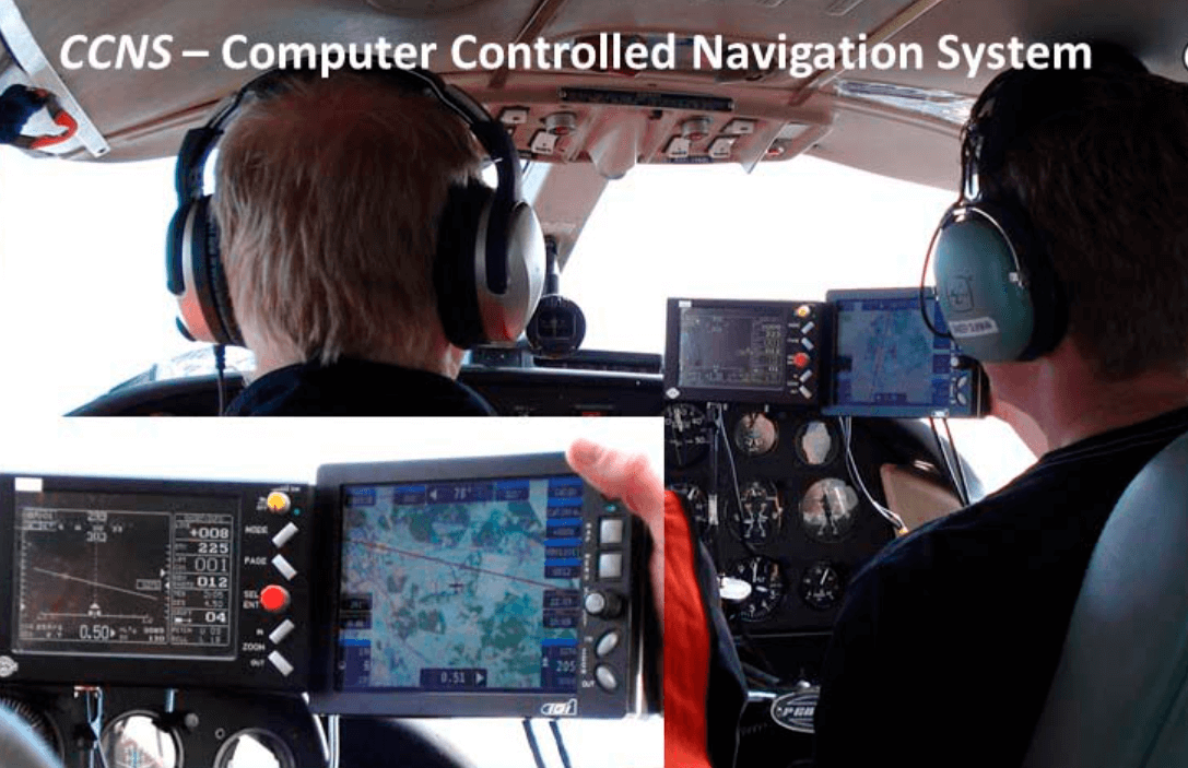
By automating routine tasks and providing decision support tools, FMS systems enhance operational efficiency, reduce pilot workload, and mitigate risks during aerial surveys.
Moreover, the integration of FMS with navigation and data acquisition systems facilitates seamless coordination between flight planning, navigation, and data collection processes, resulting in high-quality survey data and actionable insights for various applications.
8. Gyrostabilized Mounts
Our next example of aerial surveying equipment is the Gyrostabilized mount. These mounts are sophisticated gimbals used to stabilize sensors and cameras mounted in airborne platforms.
These mounts utilize gyroscopes to counteract the effects of platform motion, such as vibrations, pitch, roll and yaw angles which present a constant challenge for aerial photography, geospatial data acquisition and surveillance.
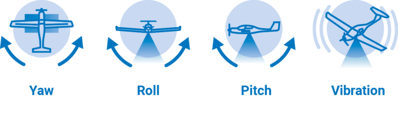
The mount ensures that the sensors maintain a stable orientation relative to the Earth's surface.
By minimizing undesired movements, gyrostabilized mounts enable the capture of high-quality imagery and data with exceptional clarity and precision, even under challenging flight conditions.
Gyrostabilized mounts can be used to stabilize lidar and large format and medium format camera sensors inside airplanes, helicopters or UAVs.
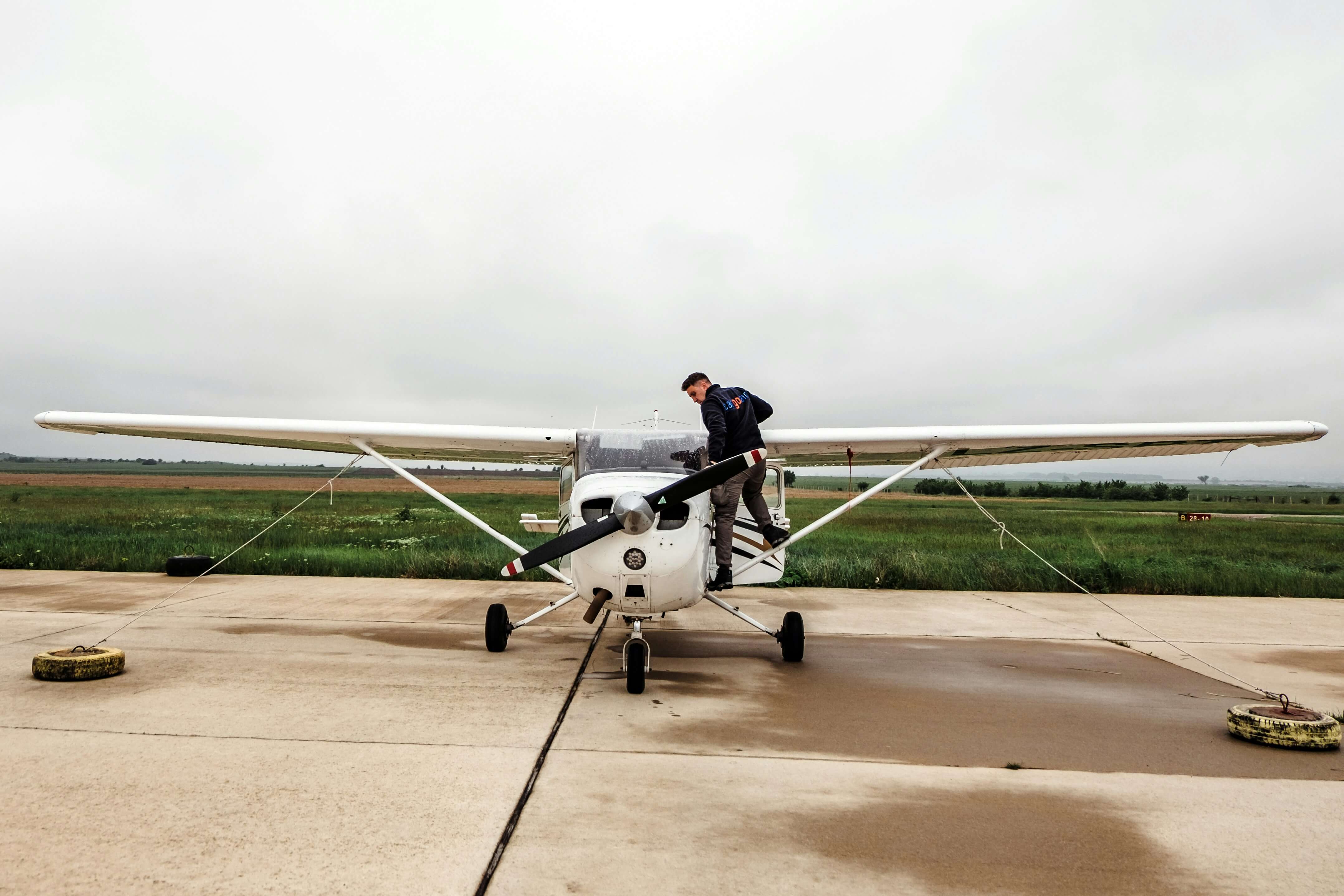
9. Manned Aerial Survey Aircraft
Manned aircraft for surveysequipped with single or dual hatches for aerial survey equipment are purpose-built platforms designed to accommodate specialized sensors and instruments for data collection.
These aircraft feature carefully engineered hatches that allow for the installation and operation of various surveying equipment, including LiDAR systems, cameras, and other remote sensing devices.
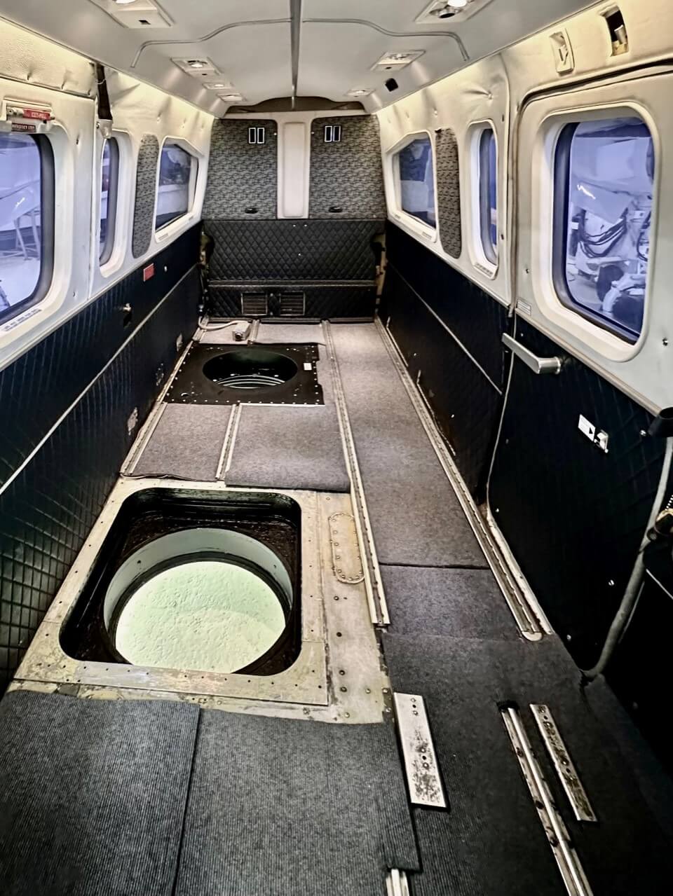
The hatches are strategically positioned to ensure optimal sensor placement and unobstructed views of the survey area.
Some models of aircraft require the addition of an exhaust extension to ensure that the exhaust gasses do not interfere with the sensors as they take photos or as lidar pulses are emitted and returned.
Survey aircraft with hatches offer flexibility and versatility, allowing for the customization and integration of different sensor configurations to meet the specific requirements of each surveying mission. Moreover, these aircraft are typically equipped with advanced avionics and navigation systems to support precise navigation and data acquisition, ensuring reliable and efficient survey operations..
10. Unmanned Aerial Vehicles (UAVs)
Our last featured type of aerial surveying equipment are Unmanned Aerial Vehicles (UAVs). UAVs have revolutionized aerial surveying with their versatility, accessibility, and cost-effectiveness.
These remotely piloted drones offer a wide range of capabilities, making them invaluable tools for aerial surveying across various industries.
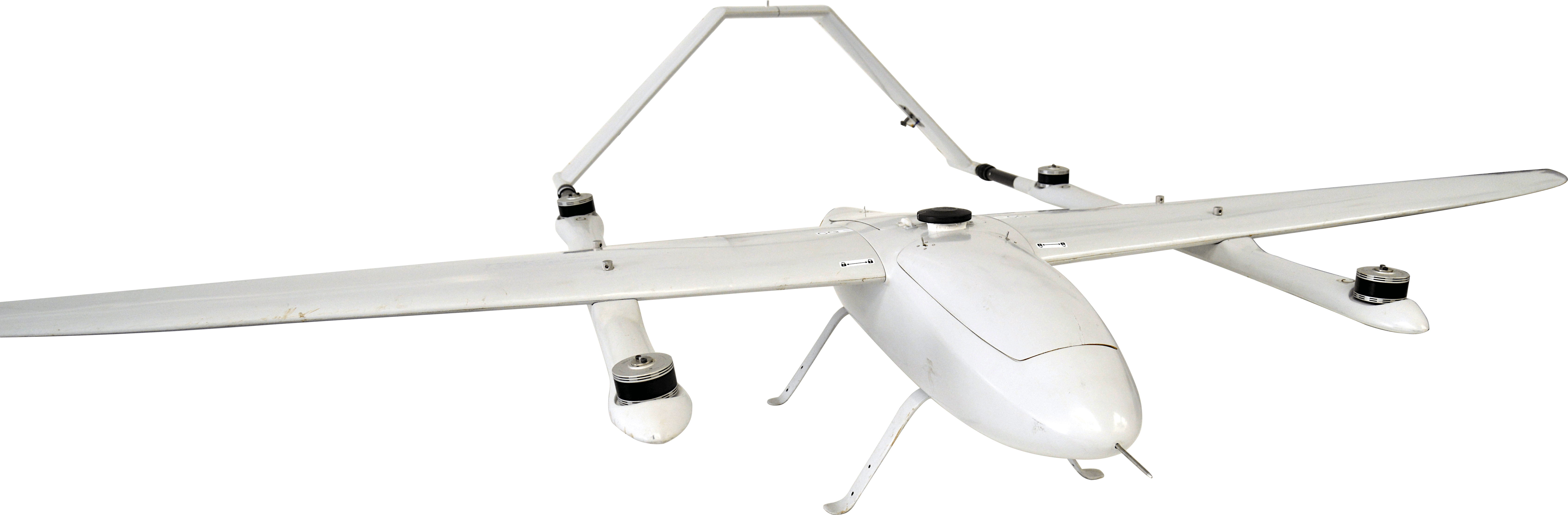
UAVs come in various sizes, from small quadcopters to fixed-wing aircraft, each tailored to specific surveying requirements.
Equipped with advanced sensors and cameras, UAVs can capture high-resolution imagery, LiDAR data, multispectral imagery, and thermal infrared data, among others.
The flexibility of UAVs allows them to access remote or hazardous areas that are difficult or unsafe for manned aircraft or ground-based surveying teams to reach.
In construction and infrastructure inspection, UAVs enable the efficient and safe inspection of bridges, buildings, and other structures, reducing costs and mitigating risks associated with traditional inspection methods.
In environmental monitoring and conservation efforts, UAVs are utilized to survey wildlife populations, monitor habitat changes, and assess the impact of human activities on ecosystems.
The integration of UAVs with GPS receivers and flight planning software enables precise navigation and autonomous flight, streamlining surveying workflows and data collection processes.
Conclusion
In conclusion, aerial surveying equipment encompasses a diverse range of technologies designed to gather spatial data with precision and efficiency.
From airplanes carrying large lidar systems for wide-area mapping to drones flying light-weight cameras, each type of equipment serves unique purposes across various industries.
By harnessing the capabilities of these technologies, professionals can obtain valuable insights into the Earth's surface and make informed decisions in fields such as urban planning, environmental management, and disaster response.
At aerialsurvey.com, we can help you pull together each of these types of equipment to create the most effective and efficient system for your projects.
If you need some advice about how what equipment might best suit your project needs, contact us and we will be happy to learn about your work and make recommendations.


Company
Aerial Survey Products
Aircraft Marketplace
Cookie Preferences
