Elevate Your Understanding: Exploring Aerial Lidar for the Mapping Industry
General


Lidar (Light Detection and Ranging) technology is a cutting-edge mapping technology that scans the earth to capture incredibly precise 3D data.
In this article, we'll take you on a journey to explore the fascinating world of aerial lidar, from its working principles to its different types, advantages, and challenges.
As the demand for 3D mapping products increases, we see a corresponding increase in lidar quote requests as our clients bid on projects.
Some clients are expert photogrammetrists who want to add lidar acquisition to their services. Others are expanding into new applications for lidar and aren’t sure which sensors might be best suited for their projects.
We want all of our clients to feel like they understand the technology and can make educated purchasing decisions. This article provides an in-depth overview of how lidar technology captured from a drone, helicopter, or fixed wing aircraft works and the applications, advantages and associated challenges.
How Does Lidar Work?
Before we dive in too deep, let's start with the basics. Lidar scanners, whether terrestrial or aerial, all do the same basic thing. They send out laser pulses and then measure the time it takes for them to bounce back.

When mounted on aircraft or drones for aerial applications, the lidar emits rapid laser pulses toward the ground. When a laser pulse hits an object or the Earth's surface, it reflects back to the lidar sensor.
The sensor records the time it takes for each pulse to return to the aircraft. By knowing the speed of light, an aerial lidar system can calculate the distance between the sensor and the object that reflected the laser pulse.
Paired with a positioning system which measures position, acceleration, and velocity, we get data about the exact location of the objects reflecting the laser pulses. In essence, Lidar paints a detailed picture of the terrain below, one laser pulse at a time.
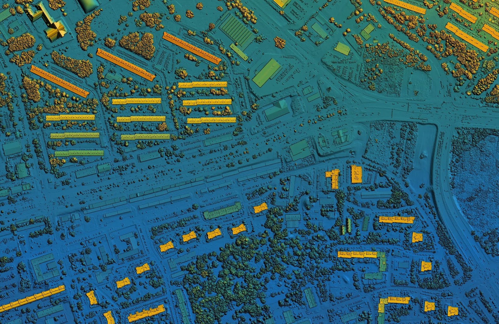
Once these laser data points are collected, they are processed to remove noise and create a 3D point cloud – a digital representation of the surveyed area. The result is a stunningly accurate map of the landscape, complete with elevation information and details about vegetation, buildings, and more.
What Are the Different Types of Aerial Lidar?
Aerial Lidar systems come in various flavors, each tailored to specific applications. Let's explore some of the most common types:
1. Topographic Lidar: This workhorse of the Lidar family is primarily used for mapping and modeling the Earth's surface. We get highly accurate elevation data for maps that focus on terrain mapping, flood modeling, and land surveying.
2. Vegetation Penetration Lidar: Designed to cut through the dense foliage, vegetation lidar can capture detailed information

about forests and vegetated areas to assess forest structure, biomass, and health, making it invaluable for forestry management
and environmental monitoring. These topographic lidar feature powerful lasers with high return rates that enable them to penetrate the many layers of vegetation in order to generate detailed 3D images of the vegetation structure.
3. City and Urban Lidar: Vital for urban planning, transportation engineering, and 3D city modeling, urban aerial lidar systems are specialized to capture 3D data of buildings and structures. They often feature rotating mirrors or prisms to capture data from multiple angles.
4. Bathymetric Lidar: Specialized lidar can be used in mapping underwater features, particularly for coastlines. Bathymetric lidar

measures water depth and underwater terrain. Water has different optical properties than air, particularly when it comes to the absorption and scattering of light. Bathymetric lidar use green laser wavelengths suitable for penetrating water more effectively, reduce scattering for more accurate measurements, and provide stronger return signals.
What Are Lidar Pulse Returns?
We know that lidar fundamentally uses laser pulses then measures the returns. Understanding how these pulses behave is crucial for data accuracy and interpretation. Here are some key points to keep in mind:
Intensity Information: As the lidar scans, the intensity of the pulses are recorded. This data is used in distinguishing between different types of surfaces. For example, they can help differentiate between the ground, vegetation, and buildings.
Multiple Returns: In some cases, a single laser pulse can produce multiple returns. For instance, it might first hit a tree canopy and then the ground. Differentiating and correctly attributing these multiple returns to their respective surfaces is an important part of post-processing work to produce accurate maps.

Point Density: The density of laser pulses affects the level of detail and accuracy in the generated point cloud. Higher point density results in more detailed data but may require more time and resources in data acquisition and post-processing.
Data Processing: Lidar data goes through extensive processing to remove noise, classify points by surface type, and generate the final 3D point cloud. Data processing is a critical step in ensuring the accuracy and usability of the collected data.
How Altitude Can Affect Point Density.
How high should you fly? Altitude plays a significant role in determining the point density and coverage of an aerial lidar survey. Here's how altitude can impact your lidar data:
Fly High and Fast: Flying at a higher altitude allows for more efficient coverage for large-scale mapping projects, but may result in lower point density. This means fewer laser pulses are returned per unit area, which may lead to reduced detail in the data.

This is why we often recommend to our clients to consider lidar sensors like the Riegl 1560 series or the Optech T2000. These powerful lidar systems acquire high accuracy data when integrated into manned aircraft covering large areas.
Fly Low and Slow: Lower altitude flights result in higher point density, capturing more details in the terrain. However, this comes at the cost of reduced coverage area, meaning more flight lines or passes may be needed to cover the same area adequately.
Choosing the right altitude depends on the specific project requirements. It's a balancing act between the desired level of detail and the efficiency of data collection. We’re always happy to consult with you to determine the best system for your platform or project.
What Are the Advantages of Aerial Lidar Over Traditional Terrestrial Lidar?
While both aerial and terrestrial lidar have their strengths, aerial lidar offers several distinct advantages.
Aerial Lidar:
- Can cover vast areas quickly, making it ideal for large-scale mapping and regional surveys that would be time-consuming with terrestrial lidar.
- Can capture data from remote or inaccessible terrain, such as dense forests, mountainous regions, and bodies of water, where terrestrial lidar may not be feasible.
- Encounters fewer obstructions (e.g., vegetation, buildings) between the sensor and the ground, resulting in less interference with data collection.
- Requires fewer ground control points for georeferencing, reducing the need for extensive fieldwork.
What are Some Challenges to Consider?
Aerial lidar does come with its own set of challenges compared to terrestrial lidar:
- Equipment and data acquisition can be expensive, particularly for high-resolution surveys.
- Sophisticated post-processing work is needed to correct for terrain undulation, atmospheric effects, and more.
- Massive amounts of data collected during aerial surveys can overwhelm storage and processing capabilities.
In conclusion, Aerial lidar is a powerful tool for capturing detailed and precise geospatial information. Lidar enables us to capture accurate 3D data of the earth to create maps for many critical applications, ranging from urban planning and environmental monitoring to disaster management, as well as for infrastructure and environmental monitoring. To see all of the lidar we currently have for sale, visit our website.


Company
Aerial Survey Products
Aircraft Marketplace
Cookie Preferences
