Exploring Geospatial Technology: Understanding its Significance and Applications
General


Introduction
At AERIALSURVEY.com, our focus is on all the gear that our clients use to acquire mapping data. How does all this technology help to acquire data, and how is that data used? Geospatial technology is revolutionizing the way we interact with and understand our world. From tracking natural disasters to optimizing supply chains, it plays a pivotal role in countless industries. In this article, we'll delve deep into geospatial technology, its various components, applications, and why it's so crucial in today's data-driven world.

What is Geospatial Data?
Geospatial data refers to the information collected about specific geographic locations on the Earth's surface.
Think about it like this: For every place on earth, there is data that can describe in in several ways:
- Location - often using coordinates such as latitude and longitude.
- Attributes- characteristics or features of the location, such as altitude or weather events at that location, temperature, aridity, etc.
- Time - what the characteristics or location are like at a specific time or span of time
Geospatial data is collected from a wide range of sources, including Global Positioning System (GPS) satellites, remote sensing technologies such as lidar, cameras, and other sensors, surveys, and even crowd-sourced data.
This data can be categorized into different types:

- Vector data: represents points, lines, and polygons and is used to represent geographic features with discrete boundaries (e.g., streets, land parcels, administrative boundaries, etc.)
- Raster data: such as gridded imagery, satellite imagery, etc. often used for mapping and analysis.
How is Geospatial Data Used?
Geospatial data provide invaluable insights for decision-makers across diverse industries.
- Environmental Conservation and Management - for example, geospatial data is used by Conservationists to protect endangered species
- Disaster management - teams rely on geospatial data to predict and rapidly respond to natural disasters effectively.
- Agriculture and Precision Farming - data helps farmers monitor crop health, assess soil conditions, and precisely apply fertilizers and irrigation, leading to higher yields and sustainable farming practices
- Urban Planning and Development - city planners and architects use geospatial data to design efficient urban landscapes, develop infrastructure, manage traffic, and plan public transportation
- Transportation and Logistics - data helps in route planning, supply chain management, and vehicle tracking
Leading Geospatial Technologies
Geospatial technology encompasses various cutting-edge tools, including:
A. Remote Sensing Technologies and Their Challenges
Remote sensing involves capturing information about the Earth's surface at a distance: This includes:

Satellite imagery - Satellites equipped with specialized sensors, cameras, and instruments capture images and data from space. Data is then transmitted back to Earth for processing in the form of high-resolution images, temperature measurements, and other geospatial information.
Using satellite technology for geospatial data comes with several challenges.
- Satellites capture images of large areas, but the spatial resolution (level of detail) can be limited. This can make it challenging to discern fine features on the ground, especially in densely populated or complex terrain.
- Cloud cover and adverse weather conditions can obstruct satellite imagery acquisition.
- Satellites may not pass over a specific area frequently enough to capture real-time or near-real-time data. This can be problematic for applications requiring frequent updates, such as weather monitoring or disaster response.
- Cost: Accessing high-quality satellite imagery can be costly, limiting its availability for some organizations and researchers. Some satellite data sources have restrictions on access and usage, which can be complex to navigate. Licensing agreements may limit the redistribution or modification of imagery.
Aerial photography - this type of geospatial technology involves capturing images from visible light cameras, infrared cameras, and multispectral cameras from an aircraft or drone. For wide area mapping and urban planning, large-format aerial survey cameras are used to efficiently capture images and do city mapping.
Challenges with this technology include:

- Cost: Aerial photography incurs expenses related to aircraft, specialized camera equipment, skilled personnel, and data processing. Large or extensive regions may require multiple flights for comprehensive coverage. The need for repeated flights can increase costs and complicate logistical planning, especially for projects covering vast territories.
- Weather Dependence: Aerial photography is highly dependent on weather conditions. Fog, rain, or high winds can disrupt data acquisition schedules, leading to delays and potential data gaps.
- Data Processing: Aerial photographs often require extensive post-processing to correct distortions, enhance image quality, and orthorectify images for accurate georeferencing.
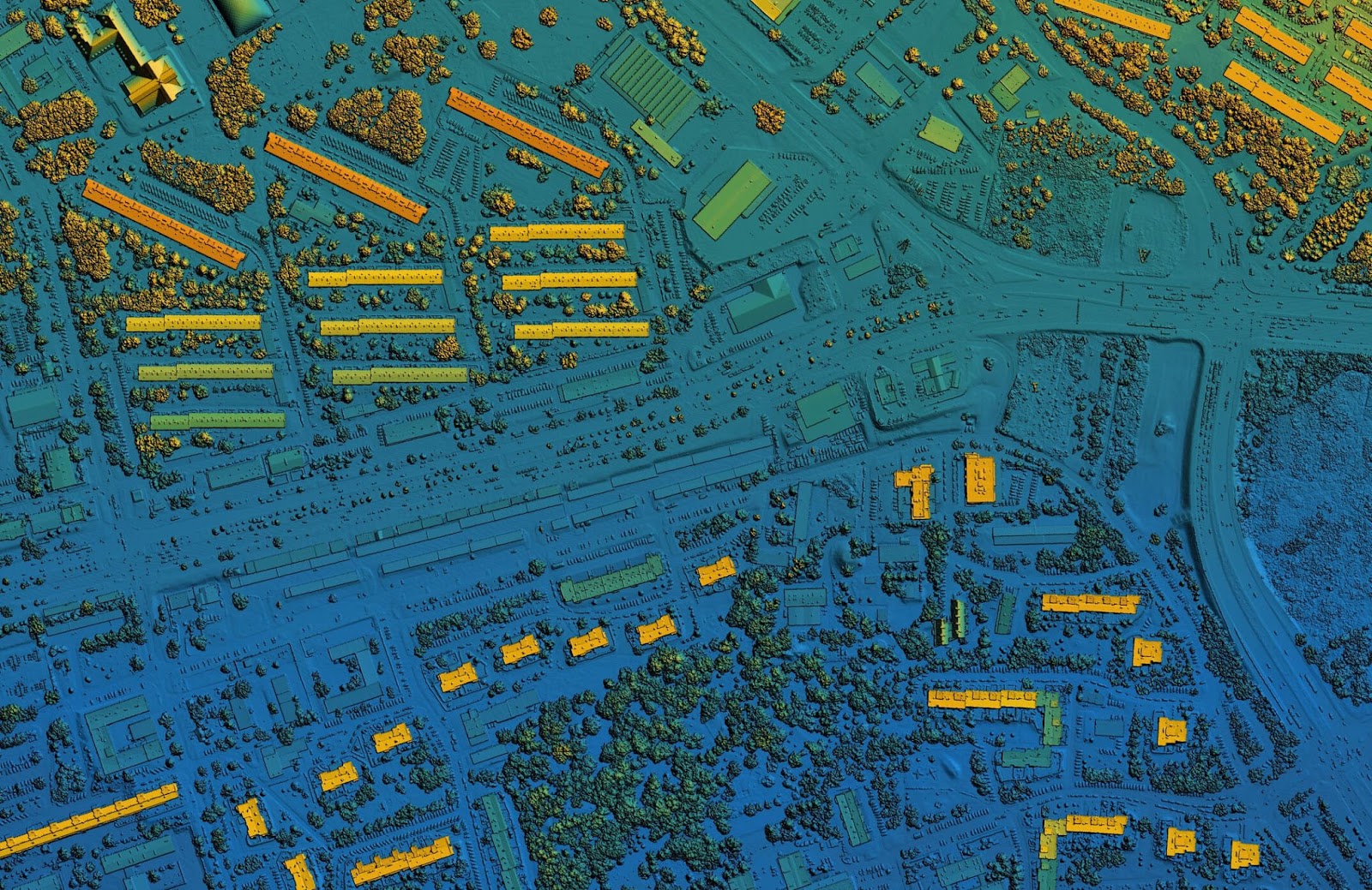
Lidar technology - these sensors use laser pulses to measure distances between the sensor and objects on the Earth's surface. As the lidar sensor scans its surroundings, it generates a dense collection of individual data points referred to as a "point cloud." Point clouds are used to create high-resolution 3D digital elevation models (DEMs) and digital surface models (DSMs).
Challenges with lidar technology include:
- Cost: Lidar can be expensive to deploy and operate, as well as the expenses incurred related to aircraft or ground vehicles for data collection.
- Data Processing and Storage: lidar data generates large volumes of highly detailed point cloud information. Handling, processing, and storing this data can be resource-intensive.
- Data Quality and Calibration: Factors such as sensor calibration, atmospheric conditions, and ground control points are critical for achieving high-quality data from this geospatial technology. Calibration efforts are necessary to correct for distortions and errors in the data, and the process can be complex and time-consuming.
B. Global Positioning System (GPS)
GPS is a positioning technology that relies on signals from a network of satellites to determine precise locations on Earth's surface. It is often used to georeference data collected during remote sensing missions. This spatial reference is essential for accurately interpreting and analyzing remote sensing data.
C. Geographic Information Systems (GIS)
GIS technology combines data collection, storage, analysis, and visualization to provide powerful insights. It serves as a comprehensive platform for integrating various forms of geospatial data, including maps, satellite imagery, aerial photographs, and survey data. One of the core strengths of GIS is its ability to perform spatial analysis. GIS maps and visualizations help users understand spatial relationships and patterns using techniques such as overlaying different data layers, proximity analysis, temporal changes, network analysis, and spatial modeling.

Why is Geospatial Technology Important?
The data captured by geospatial technology provides decision-makers with visual and spatial context to enable informed choices. Geospatial data plays an increasingly integral role in everyday life, impacting our daily routines and decisions. How might you be using geospatial data today?
- Navigation and GPS: GPS technology relies on geospatial data to provide real-time navigation and location-based services. It guides us when driving, walking, or biking, helping us find the quickest routes, locate businesses, and estimate arrival times.
- Smartphone Apps: Many smartphone apps, from ride-sharing services to weather apps, use geospatial data to enhance user experiences. For instance, weather apps use geospatial information to provide localized forecasts.
- Online Mapping Services: Google Maps and Apple Maps are powered by geospatial data. They help us find directions, discover nearby businesses, and explore points of interest.

- E-commerce and Delivery Services: Did your Amazon delivery arrive on time? E-commerce companies use geospatial data for supply chain management, order tracking, and delivery route optimization. It ensures that packages are delivered efficiently to our doorstep.
- Social Media and Location Sharing: Social media platforms often allow users to share their location with friends and family. Geospatial data is used to display their location on maps and provide location-based recommendations.
- Emergency Services: Geospatial data is crucial for emergency response. When we call 911, dispatchers use our location data to send help to the correct address quickly. Similarly, mobile apps can provide location data to emergency services.
- Real Estate and Property Search: Real estate websites and apps use geospatial data to display property listings on maps. Buyers and renters can explore properties in specific locations and neighborhoods.
- Travel and Tourism: Travelers use geospatial data to plan vacations, locate hotels, and explore tourist attractions.
Conclusion
Geospatial technology is more than just a tool; it's a transformational force that shapes our world. And this technology is evolving and improving every year. We partner with many of the world’s leading manufacturers to make sure that we understand how this technology can best support our client’s needs. If you’re not sure which remote sensing technology is most appropriate for your projects, don’t hesitate to contact us and we’ll be happy to help you.


Company
Aerial Survey Products
Aircraft Marketplace
Cookie Preferences
