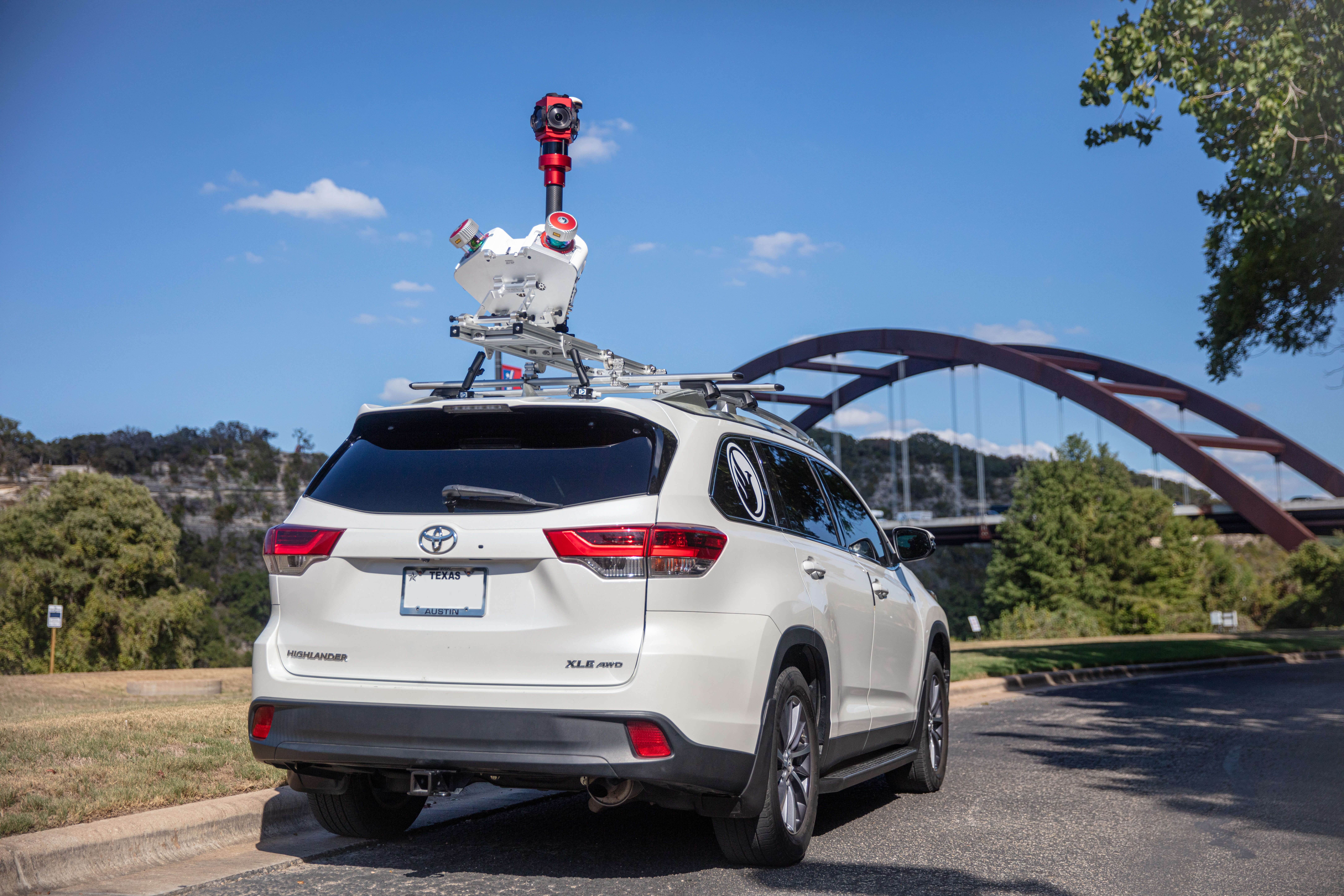
Phoenix Lidar Systems: Multi-Platform Sensors for Powerful 3D Scanning
Lidar

Have you noticed? ClearSkies Geomatics now offers new with warranty Phoenix Lidar Systems for purchase or rent through AERIALSURVEY.com.
If you're navigating the landscape of cutting-edge lidar solutions, you may be wondering how to maximize your investment with these turnkey systems.
In this article, we'll delve into three Phoenix Lidar Systems, shining a spotlight on the Ranger Flex Dual Mobile scanner, the Ranger LR22-Lite, and Ranger XL.
How do you scan? By backpack? UAV? SUV? Helicopter? Let’s see how these multi-platform systems can flex to your need.
The Ranger Flex Dual Mobile Scanner
We saw the Ranger Flex Dual Mobile scanner first at Intergeo 2023, and knew right away that this would be an excellent lidar mobile mapping system to offer our client base. It's a multi-platform workhorse.

The Ranger Flex Dual Mobile scanner accessory kit enables surveyors to utilize two RANGER-UAV22 FLEX single scanners together, providing an extremely flexible system.
The physical arrangement of the dual scanners is strategically designed to deliver substantial time savings on-site while ensuring comprehensive point coverage, achieving a remarkable speed of up to 2.4 million measurements per second.

The standalone RANGER-UAV22 FLEX payload acts as the central control unit within the dual scanner mobile accessory.
When detached, it becomes a versatile tool for backpack and UAV applications, adding another layer of adaptability to your team’s capabilities.
Ranger Flex Dual Mobile scanner accessory kit enables an optimal 40 degrees tilt angle of the dual scanner platform. This gives higher mounting flexibility for various cars and trucks.
The kit also supports the addition of a 360° LadyBug 5+ or LadyBug 6 Camera with integrated SLAM Assist Hesai XT32 scanner and GNSS Antenna, making this a full-featured and powerful mobile scanning system.
This Phoenix Lidar Systems mobile scanner can be used for applications such as:
- Transportation Infrastructure Mapping
- Road Surface Inspection
- Open-pit Mining
- Railway Track Mapping
- Construction Site Surveying

Real-World Scenario
Let’s look at how this system could be used in a real-world scenario.
An inspection car travels along a railway track with the Ranger Dual Flex Mobile Scanner secured to the roof.
The system swiftly captures up to 2.4 million data points per second.
This 3D scan allows the railroad to monitor for any deviations from the standard track geometry which might signify the need for maintenance.
Overgrown vegetation can also pose a significant challenge to railway infrastructure.
The lidar operator removes one of the RANGER-UAV22 FLEX sensors and mounts it on a drone. Within minutes, you’ve taken an extremely capable mobile lidar scanner and transformed it into a powerful tool for aerial data collection.
The aerial 3D scan can detect encroaching trees, bushes, or other obstructions that could compromise the safety and integrity of railway tracks.
This proactive approach allows rail operators to schedule timely vegetation clearance, reducing the risk of obstructions or damage.
Spotlight on the RANGER-LR22-LITE
Moving forward in our exploration of Phoenix Lidar Systems, let's focus our lens on the Ranger LR-Lite. Short for "Long Range Lite," this lidar system lives up to its name by delivering exceptional performance in capturing data over extended distances.
The tag line for this system says it all: FLY IT, DRIVE IT, MOUNT IT ANYWHERE. THE MOST ADAPTABLE MAPPING SYSTEM
Designed for a variety of complex mapping applications, the RANGER-LR22 LITE is the perfect combination of high density, long range LiDAR with a powerful 1,550 nm laser and up to 15 returns that penetrate dense vegetation at high speeds and altitudes in large scan regions.

A true multi-platform solution, this turnkey system which features the Riegl VUX-LR22 lidar sensor can be configured to fly on drones, helicopters, vehicles for mobile mapping, VTOL aircraft and even be used in a backpack configuration.
It is one of the most precise sensors you can fly at a variety of altitudes.
Fly on a drone up to 400 feet AGL at 8 meters per second and collect over 190 points per square meter in a single pass.
Or, mount the Ranger LR on a helicopter and fly at 550 feet AGL at 55 knots, and achieve 30 points per square meter on a single pass (depending on your measurement rate setting).
With a 360 degree FOV, the Ranger LR is capable of up to 15 target returns per laser pulse, making a superb choice for enhanced mapping of dense vegetation.
Because of its efficiency and accuracy, the RANGER-LR22 LITE is ideally suited for:
- Oil and gas surveying
- Utilities mapping
- Railway track mapping
- Agriculture and forestry monitoring
- Construction site surveying
- Open-pit mining operations
- General mapping
Real-World Scenario
A building site requires a “Digital Twin” 3D map to be created that shows the layout of buildings and the existing pipe and equipment structure.
Using the RANGER-LR22 LITE, data can be gathered first by mounting it on a vehicle, and then mounting it on a UAV for an aerial view.
The aerial and mobile point clouds can then be merged into a single cohesive dataset, along with camera images to create a user-friendly map that enables end users to digitally “visit” the site and make key decisions on improvements and maintenance.
Exploring the Flexibility of the Ranger XL
Our journey through the Phoenix Lidar Systems Ranger series wouldn't be complete without a closer look at the Ranger XL.

The Ranger-XL is a lightweight airborne laser scanner, specially designed for use on UAS, helicopters, or fixed-wing manned aircraft. With a 75 degrees field of view and an extremely fast data acquisition rate of up to 1800 kHz, the Ranger-XL is perfectly suited for high point density corridor mapping applications such as power line, railway track and pipeline inspection. Combining the Ranger XL with Phoenix Lidar’s Pod solution for aircraft such as the Cessna 172, 182, or 206 allows for a user-friendly, streamlined mounting solution for large scale missions.
Let’s look at some of the key features of the Ranger-XL
- Easily mountable to unmanned platforms (UAVs), helicopters, or fixed-wing aircraft
- Operating flight altitude up to 1,400 m / 4,600 ft
- Scan speed up to 400 lines/second
- Available with several options for accessories to enhance it’s flexibility

Real-world Scenario
For large scale land redevelopment, there is a lot of information needed before the planning stage can even begin.
Considerations for topography, ground cover types, vegetation health, and watershed delineation are just a few of the factors that go into assessing a large plot of land.
Collecting all of this information efficiently and accurately could pose a large problem before the project even gets off the ground.
However, Phoenix Lidar Systems can integrate a wide variety of camera options with the Ranger XL, including a 4-Band multispectral camera.
Tying together the precise lidar scans with the 4-Band imagery allows for an incredible amount of data to be collected with each pass of the system.
The flexible mounting options of the Ranger XL allow thousands of acres to be collected by drone in a matter of days.
Mount the system to the nose of a helicopter and collect that same area in a matter of hours.
Phoenix Lidar Systems’ software facilitates the fusion of each data type into an astounding data product that can function as a repository of information to be used for a wide variety of assessments throughout the land redevelopment project.
Multi-Platform Capabilities: Scanners that Flex to the Project
What ties these Phoenix Lidar Systems together is their multi-platform capabilities.
Our clients come to us looking for solutions that help them to maximize their investments, and in an industry where flexibility is key, these integrated lidar systems can address our client’s varied project needs and platforms.
The Ranger Flex Dual Mobile scanner, Ranger LR-Lite, and Ranger-XL redefine the landscape of 3D scanning through their multi-platform capabilities and unparalleled flexibility.
To learn more about how you can access these flexible, multi-platform lidar systems for purchase or rent, see them on the Phoenix page on AERIALSURVEY.com.
Thank you to Will Racid and Joshua Kornoff from Phoenix Lidar Systems for their support in writing this article.


.jpeg)


