
Your account is currently pending and is under review by our staff.
You've reached your limit. Upgrade to increase listings!
Below is a reproduction of a press release from Riegl International from January 29, 2024.

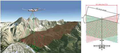
ClearSkies Geomatics Inc. (Colorado, USA) has invested in a RIEGL VQ-1560 II-S Airborne Laser Scanner as the foundation of their fleet of rental systems. The VQ-1560 II-S follows the successful concept of RIEGL’s proven dual channel laser scanner series. With increased laser power the operational altitudes are extended up to 1700 m AGL at a pulse repetition rate of 4 MHz, or up to 3900 m AGL at a pulse repetition rate of 540 kHz (all values given for 20% target reflectance). These improved maximum ranges allow an increase in the system’s productivity of about 25% for a very attractive point density range. Laser pulse repetition rates can be fine-tuned in 12 kHz steps, enabling subtle optimization of acquisition parameters to meet specific project requirements. With its unique cross-fire scan pattern allowing the maximum wide-area coverage for various forestry and corridor applications, the VQ- 1560 II-S has become the flagship airborne system for the industry.
“We are extremely pleased that ClearSkies has committed and invested in RIEGL aerial sensors and technologies to enable existing and future customers in their short-term capacity requirements.” commented Michael Sitar, Airborne Division Manager for RIEGL USA. “ClearSkies presented to us a unique business model designed to support the aerial survey industry with access to the latest in aerial LiDAR sensor solutions for mid to large collection programs.”
ClearSkies Geomatics Inc. is an industry leader within the geospatial community. The company’s experience with many different remote sensing platforms and technologies is especially in tune with the needs of clients with large project requirements and inquiries as to the best solutions for their needs. ClearSkies commitment to purchase a RIEGL VQ-1560 II-S ensures that the airborne community will be equipped with the correct solution.
.webp)
“ClearSkies Geomatics is thrilled to be able to offer our clients around the world with the opportunity to rent this high-accuracy RIEGL VQ-1560 II-S.” said Patrick McConnell, President of ClearSkies Geomatics Inc. “This sensor system will be our premier system available for short-term rentals and enables us to meet this important need in the aerial survey industry. RIEGL USA’s support for our growing sensor rental services is critical for our success and we look forward to our continued relationship.”
To learn more about the RIEGL VQ-1560 II-S and the ClearSkies rental program please visit RIEGL during GeoWeek at booth #1103 or click here to learn more about the RIEGL VQ-1560 II-S.
As the ClearSkies rental program with the VQ-1560 II-S is sure to grow and be very prosperous, RIEGL looks forward to working together more in the future and supplying needed systems as this expands its scope over time.
About RIEGL:
RIEGL is an international leading provider of cutting-edge technology in airborne, mobile, terrestrial, industrial, and unmanned laser scanning solutions for applications in surveying.
RIEGL has been producing LiDAR systems commercially for over 40 years and focuses on pulsed time-of-flight laser radar technology in multiple wavelengths.
RIEGL’s core Smart-Waveform technologies provide pure digital LiDAR signal processing, unique methodologies for resolving range ambiguities, multiple targets per laser shots, optimum distribution of measurements, calibrated amplitudes, and reflectance estimates, as well as the seamless integration and calibration of systems.
RIEGL’s Ultimate LiDARTM 3D scanners offer a wide array of performance characteristics and serve as a platform for continuing Innovation in 3D for the LiDAR industry.
From the first inquiry, to purchase and integration of the system, as well as training and support, RIEGL maintains an outstanding history of reliability and support to their customers.
Worldwide sales, training, support, and services are delivered from RIEGL’s headquarters in Austria and in the USA; main offices in, Japan, China, Australia, Canada, and the UK; and a worldwide network of representatives.
About ClearSkies Geomatics, Inc:

ClearSkies Geomatics, Inc is a leading provider of geospatial solutions, offering high-quality aerial survey equipment rentals, brokerage, and reseller services through the AERIALSURVEY.COM portal. We are deeply experienced with remote sensing technologies such as lidar solutions, photogrammetric hardware/software, medium and large format survey cameras, and aircraft platforms. With headquarters in Boulder, CO, ClearSkies Geomatics is committed to delivering exceptional products and support to clients worldwide. For more information, visit aerialsurvey.com.


